Neogene/Quaternary highstand depositional processes
Allen Lowrie, S.J. Moffett, T.C. Kickamp, R. Hamiter
Consultants
A complex of synergistic processes combine to create Holocene highstand sedimentation patterns. Global climatic change affects sea level and the distribution of atmospheric cells (Hadley, Ferrel and Polar), thereby shifting the boundaries of temperature, precipitation and terrestrial vegetation zones. Also involved is the regional occurrence of oceanographic western boundary intensification and its impact on local meteorology.
Weathering rates are affected, thus influencing the rate and type of terrestrial sediment input. Regional tectonics and sediment accommodation space is also significant. All of the above can influence Holocene transgressive and highstand deposition.
The intensity of these inputs varies with the amplitude of the climatic cycle, whether as fourth order (~104 year) oscillations modulated by fifth order (~103 year), sixth order (~102 year) and seventh order (~101 year) categories. Each oscillation will affect the erosion, transportation and deposition continuum.
Climatic/sea-level oscillations (of millennial periodicity and about 1 meter range) are well-documented especially for northern temperate latitudes. Proxies for climate change include carbon fourteen (C14) fluxes, tree line elevations, and archeological positions of ancient seaports. Historical records and the initiation of the Belize Delta at the mouth of the Mississippi River document the occurrence of the Little Ice Age, which began in the early 1300s.
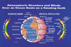
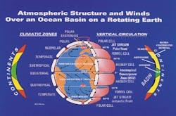
Atmospheric structure and winds over an ocean basin on a rotating earth with idealized sediment depositional regimes worldwide.The main objectives of this study are input description and input quantification, such as rate ranges. The inputs provided by historical data (such as river flow, precipitation rates, temperature, and sea level changes) yield a basis for extrapolating back to prehistoric times. A Holocene description applies to similar highstand phases of the Quaternary, probably as well as the Neogene.
Background
The Holocene is the youngest geologic epoch, beginning 11,000 years ago with elevated global temperatures and subsequent marine transgression. It followed the Younger-Dryas event, which represented a brief (~1,000 year) return to cold conditions during the interglacial warming. Eustatic sea level rose to present heights in the mid-Holocene approximately 7,000 years ago. Subsequent history was marked by fifth and sixth order sea-level oscillations with ranges of a meter or less as the regression phase began.Eustatic sea-level oscillation is the major factor to impact Holocene deposition. Subsequent to a marine transgression, correlative processes occur including: isostatic uplift, erosion, sediment transportation, and deposition.
Depositional environments for Quaternary and probably Neogene, highstands such as the Holocene, are characteristically expressed as fluvial, deltaic, coastal, inner- and mid-continental regimes.
Controls on sediment deposition include climate (atmospheric conditions and oscillation frequency), sea-level position, rate and type of sediment input and sediment accommodation space, as well as local and regional tectonics.
Climatic change initiates numerous geologic processes. It is time-dependent, a fourth dimension, super-imposed on the "normal" geographical or three-dimensional range of processes. General global climate patterns for the Holocene and previous highstand phases are represented by the distribution of atmospheric cells, notably the Polar (~60°- 90° latitude), Ferrel (~30°- 60° latitude) and Hadley (~0°- 30° latitude) cells.
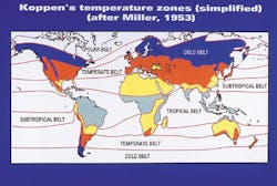
Unequal heating of the Earth's surface and the Coriolis effect combine to create the planetary atmospheric patterns (Summerhayes and Thorpe, 1996). These planetary patterns of atmospheric cells from equator to poles divide global meteorology in uneven belts of iso-atmospheric conditions, latitudinal bands of generally uniform meteorology, with similar temperature ranges and rates of precipitation. Global temperature zones include polar, cold, temperate, subtropical and tropical belts.
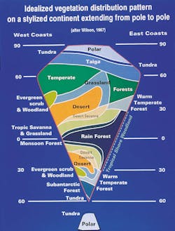
Vegetation controls the impact of precipitation and influences rates of erosion. Shown graphically is an idealized distribution of vegetation across a stylized continent extending from pole to pole. Tundra and taiga coincides with the Polar atmospheric cell. Temperate forests and grassland (prairies) are found within the boundaries of the Ferrel atmospheric cells. The Inter-Tropical Front which is located between the Ferrel and Hadley atmospheric cells marks the borders of desert (temperate and subtropical) and desert savanna. Tropical rainforests, monsoon forests, tropical savannas and grasslands occur within the boundaries of the Hadley atmospheric cells.
There have been climatic fluctuations throughout geologic history. The Quaternary and Neogene has been punctuated by glacial and interglacial stages that are climatic precursors to lowstand and highstand deposition, respectively (Vail, 1987). For the Holocene interglacial, the Polar, Ferrel and Hadley atmospheric cells extend from 60°- 90°, 30°- 60° and 0°- 30° latitude, respectively. During glacial intervals (periods of lowstand deposition), a rough estimate of latitudinal ranges for atmospheric cells would span 40°- 90° (Polar), 20° to 40°- 50° (Ferrel) and 0°- 25° (Hadley).
The amplitude of climatic oscillation, expressed in latitudinal ranges of atmospheric cells, during interglacial periods is of lesser magnitude than during glacial epochs. Latitudinal shifts/expansions of atmospheric cell boundaries during interglacial periods may be only a few degrees, generally less than 500 - 1,000 km. The Holocene has been characterized by millennial climatic oscillations (Rampino et al, 1987; Morner and Karlen, 1994; Finkl, 1995). These cycles were accompanied by global temperature fluctuations of 1°- 2° C, but local effects were much greater. The global temperature difference between a full glacial and an interglacial is approximately 10°C (R.W. Fairbridge, personal communication). Thus, the 1°- 2° C variation in Holocene temperature is approximately 10-20% of the temperature swing associated with the transition from glacial to interglacial conditions.
Idealized temperature distribution worldwide.The position of the subtropical front can vary in excess of 10° in latitude between full glacial and peak interglacial conditions. The position of the Polar Front has been shown to shift up to 15° in latitude. Assuming that these climatic transitions, or similar shifts associated with millennial changes within the Holocene, are linear, then a 10-20% change would represent a 1°- 3° latitudinal shift in frontal boundary positions.
Another control on sediment deposition is the rate and type of sediment input to the continental margins. Most of the sediments along continental margins are "relict." These sediments were deposited during the last Ice Age when lower sea levels resulted in massive sediment deposition onto the outer shelf and slope. Reworking of original sediments and Holocene detrital deposition erase imprints from earlier times. Sediments are divided into four classes:
Biogenic sediments are mainly concentrated near the equator, in the zone of the Inter-Tropical Convergence (ITC).Idealized patterns of worldwide vegetation distribution.
In summary, planetary atmospheric and general depositional patterns along continental shelves have regional correlation. Atmospheric conditions fuel evapo-transpiration that supplies precipitation, which controls rates of fluvial, lacustrine and coastal deposition. In addition to climate, local and regional tectonic regimes can influence rates of erosion and sediment deposition.
Small, mountainous rivers, located between 0°- 30° latitude and, generally along active plate margins, can produce massive erosion rates. Steep gradients and tropical rainfall characterize these rivers (Milliman, 1995). Sediment discharge from such rivers may be 10-30 times greater than discharge from a comparable drainage area across the coastal plain of a passive margin (Milliman, 1995).
Extensive sub-humid to semi-arid to arid regions are located from 30°- 60° latitude. The regional lack of precipitation is equated with an absence of fluvial sediment transport. An ephemeral river in Israel may be up to 400 times more efficient at transporting coarse material than a comparably-sized perennial rivers in humid regions.
With the temperate portion of the 30°- 60° latitude zone, there are two end-members of deposition (Nittouer and Kravitz, 1996). Two examples are found along an active and a passive continental margin, in northern California and New Jersey, respectively. In northern California, the relatively short Eel River discharges 107 tons/year onto a shelf that ranges from approximately 10-20 km wide. Local failure of shelf and slope sediments is linked to rapid sedimentation, frequency of earthquakes and strong current activity. Note that there has been little regional subsidence.
On the New Jersey continental margin, terrigenous sediments are stored in river estuaries (Hudson and Delaware rivers) and behind barrier islands. Due to the present marine transgranssion, sands cover the continental shelf while silts and clays are deposited contemporaneously in local depressions. This is an area of active subsidence.
The surface sediments, a product of the most recent marine transgression, cover the previous highstand deposits. There are alternating layers of prograded and aggraded transgressive and highstand sediments thousands of meters thick which represent the Quaternary and most of the Tertiary (Nittouer and Kravitz, 1996). A similar depositional regime exists on the continental shelf of the Gulf of Mexico.
An additional tectonic component incorporates isostatic uplift which affects the portion of the Northern Hemisphere (north of 50°-60°N) covered by glaciers during the last glaciation. Sediments are deposited and eroded at wave base due to isostatic rebound.
There is a loose, yet definite correlation between planetary atmospheric patterns and sediment deposition along the world's continental shelves. Climate provides the mechanism for sediment erosion, transportation and deposition. The table summarizes these relationships.
Millennial and shorter-scale climatic oscillations can shift/expand the boundaries of atmospheric cells that affect depositional patterns. By understanding the processes that impact Holocene sedimentation patterns, we may better describe past interglacial depositional environments of the Quaternary and Neogene.
References:
- Bloom, A.L., 1991. Geomorphology: A Systematic Analysis of Late Cenozoic Lanforms, Second Edition; Prentice-Hall, New Jersey, p. 311-312.
- Finkl, C.W. (ed), 1995. Holocene cycles: Climate, Sea Levels, and Sedimentation; Journal of Coastal Research, Special Issue No. 17, 402 pp.
- Milliman, J.D., 1995. Sediment discharge to the ocean from small mountainous rivers: The New Guinea example; Geo-Marine Letters, v. 15, p 127-133.
- Morner, N.A. and W. Karlen, eds, 1994. Climate Changes on a Yearly to Millennial Basis; Reidel Dordrecht, 667 pp.
- Nittouer, C.A. and J.H. Kravitz, 1996. Stratoform: A program to study the creation and interpretation of sedimentary strata on continental margins; Oceanography, v. 9, no. 3, p. 146-151.
- Rampino, M.R., J.E. Sanders, W.S. Newman, and L.K. Konigsson, eds., 1987. Climate: History, Periodicity, and Predictability; Van Nostrand Reinhold, New York, 588p.
- Summerhayes, C.P. and S.A. Thorpe, 1996. Oceanography, An Illustrated Guide; John Wiley and Sons, New York and Toronto, 352 p.
- Vail, P.R., 1987. Seismic stratigraphy interpretation using sequence stratigraphy; Part I: Seismic strati graphy interpretation procedure, in Atlas of Seismic Stratigraphy; A.W. Bally, ed.; AAPG Studies in Geology No. 27, vol. 1.
Copyright 1999 Oil & Gas Journal. All Rights Reserved.
