Offshore staff
HOUSTON –NEOS GeoSolutions Inc. has introduced the second generation of its neoSCAN geoscience data integration and analytics tool.
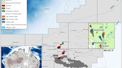
TNEOS said that neoSCAN helps geoscientists get the most value out of legacy investments ingeological and geophysical data by integrating existing, in-house geo-datasets with additional multi-physics datasets that NEOS can obtain from a variety of sources.
“Because no new geophysical data acquisition is required with a neoSCAN,” Chris Friedemann, chief commercial officer for NEOS, said, “we can deliver a rich set of interpretive products – including 3D subsurface models and maps of faults, intrusions and basement topography, and composition – in fewer than 100 days and for less than 50 cents per acre ($125 per sq km). Perhaps best of all, we still employ our proprietary predictive analytics methods on all neoSCAN projects. This allows us to develop rich insights into the G&G attributes that are associated with known fields or sweet spots in the area of investigation. By searching for these same correlative attribute suites in under-explored areas, the neoSCAN helps our clients to high-grade acreage and to focus scarce financial and human resources on the most prospective parts of the oil and gas play being assessed.”
02/24/2015


