Special chamber fixes maritime boundary between Ghana and Côte d'lvoire

Ruling may set precedent for other offshore border disputes
Pieter Bekker
CMS Cameron McKenna
Robert van de Poll
Fugro Group
Near-shore impact of Special Chamber’s choice of boundary starting point.
In a 181-page judgment delivered in Hamburg on Sept. 23, 2017, a Special Chamber of the International Tribunal for the Law of the Sea (ITLOS) unanimously fixed the course of the single, “all-purpose” maritime boundary between the Republic of Ghana and the Republic of Côte d’Ivoire both within and beyond 200 nautical miles from the two countries’ coastlines.1 The boundary, which is situated in an area in the Gulf of Guinea that is rich in hydrocarbons, represents a relatively rare “strict,” or un-adjusted, equidistance line favoring Ghana.2 The case took exactly three years to be resolved following Ghana’s surprise move to impose an adjudicated solution upon its western neighbor after bilateral negotiations spanning six years and 10 rounds did not result in an agreed boundary. As this analysis of the ruling will demonstrate, the new boundary will require adjustments to practically all existing oil and gas blocks on either side of the line.
The parties’ positions
The year 2009 marked an important milestone in the relations between Ghana and Côte d’Ivoire: it was when Ghana intensified its oil activities in the disputed area following significant discoveries—especially in the TEN (Tweneboa, Enyenra, Ntomme) field. It also saw the filing of a declaration by Ghana under Article 298 of the United Nations Convention on the Law of the Sea (UNCLOS) stating that it did not accept any of the dispute settlement procedures provided for in UNCLOS in matters of maritime boundary delimitation as well as of submissions for the extension of the continental shelf beyond 200 nautical miles to the Commission on the Limits of the Continental Shelf (CLCS)3 by both countries.
In September 2014, Ghana surprised Côte d’Ivoire by instituting proceedings before anad hoc arbitral tribunal seeking delimitation of the maritime boundary with Côte d’Ivoire in the Atlantic Ocean while withdrawing the Article 298 declaration it had made in 2009. Given that both countries are parties to UNCLOS, Ghana could rely on Annex VII of UNCLOS to sue Côte d’Ivoire and obtain an adjudicated solution to their boundary dispute. The two countries subsequently concluded a Special Agreement whereby they agreed to transfer the case to a Special Chamber of ITLOS comprising five members, with ITLOS Vice-President Boualem Bouguetaia of Algeria presiding over the proceedings.4 The case thus became the first-ever maritime boundary case submitted to an ITLOS Special Chamber.5
In the proceedings before the Special Chamber, Ghana and Côte d’Ivoire, whose coasts are convex and concave, respectively, but which otherwise are straight (i.e., not indented) and almost equal in overall length, disagreed on the approach to be taken in fixing their common maritime boundary. They also disagreed on the points along their coasts from which the boundary was to be measured, the so-called base points, and on the marine charts to be used in fixing their boundary.
Ghana maintained that both countries over several decades had mutually recognized and applied an equidistance-based maritime boundary in the 12-nautical-mi territorial sea and their Exclusive Economic Zone (EEZ) and continental shelf within 200 nautical miles from their coasts. Ghana also claimed that the countries’ 2009 submissions to the CLCS were evidence of their tacit delimitation agreement regarding the boundary beyond 200 nautical miles.
According to Ghana, the starting-point for the demarcation6 of the allegedly agreed maritime boundary was the common land boundary terminus at border post 55 (BP55), the geographic coordinates of which had been agreed by the two countries nine months before Ghana instituted proceedings.
Disagreeing with Côte d’Ivoire that the area to be delimited features geographical circumstances capable of influencing the equidistance-based maritime boundary advocated by Ghana, Ghana submitted that, if the Special Chamber did not accept that there was an agreed boundary, the provisional equidistance line to be drawn by the judges based on a 10-km segment of Ghana’s coast was to be adjusted to the west on account of the oil activities of both countries. In Ghana’s view, those activities evidenced a modus vivendi (an arrangement or agreement allowing conflicting parties to coexist peacefully, either indefinitely or until a final settlement is reached). The resulting boundary coincides with the western limit of Ghana’s oil blocks.
Ghana also asked the Special Chamber to rule that the parties’ maritime boundary beyond 200 nautical miles follows an extended equidistance boundary along the same azimuth7 as the boundary within 200 nautical mi, to the limit of national jurisdiction.
Denying that there was an expressly agreed or “customary” boundary in place between the two countries, let alone one based on equidistance, and rejecting Ghana’s reliance on oil activities in the relevant area, Côte d’Ivoire asked the Special Chamber to rule that the single maritime boundary between Ghana and Côte d’Ivoire follows the 168.7° azimuth line, which both parties agreed starts at BP55 and extends to the outer limit of the continental shelf.
The boundary that was advocated by Côte d’Ivoire is based on an angle bisector method, which along with equidistance is among the geometry-based methods for delimiting maritime boundaries recognized by international courts and tribunals.8 This method is based on the general direction of the coastal geography of two countries with adjacent coasts.
Segment-by-segment difference between final boundary and parties’ claimed lines.
According to Côte d’Ivoire, applying the bisector method was appropriate in this case given the limited number of base points and their location on what in its view constitutes an unstable coastline that is not representative of the overall coastal geography. It also pointed to the orientation of the countries’ coastlines, which runs in the opposite direction to the general direction of their coasts, as well as the circumstance that the base points (typically, low-water line points) used for the construction of the provisional equidistance line are all located on a small portion (around 10 km) of the countries’ coastlines, and all of them are situated on Jomoro. Representing only one percent of Ghana’s territory, Jomoro is an incursion into Ivorian territory that takes the form of a narrow strip of land blocking the seaward projection of part of the Ivorian land mass, and Côte d’Ivoire argued that it would create maritime entitlements for Ghana in an area exceptionally rich in hydrocarbons, especially the Tano sedimentary basin, one of West Africa’s richest basins.
Côte d’Ivoire also complained that the configuration of the narrow coastal segment employed for the construction of the equidistance line advocated by Ghana would cause a cut-off for the maritime area of Côte d’Ivoire in contravention of settled international jurisprudence and that the resulting boundary line was contrary to the objective of achieving an “equitable solution,” the result dictated by UNCLOS for boundaries in maritime areas lying beyond the territorial sea.9 Côte d’Ivoire instead identified much longer relevant coasts than Ghana, claiming its relevant coast was 510 km versus 121 km for Ghana, resulting in a ratio of approximately 1:4.2 in its favor. According to Côte d’Ivoire, this “marked disparity” in the respective lengths of the coasts was a circumstance to be taken into account as a relevant circumstance requiring adjustment to any provisional equidistance line to be made.
Côte d’Ivoire maintained that the same line could be construed based on either a bisector method or modified equidistance using the equidistance/relevant circumstances method proposed by Ghana. In Côte d’Ivoire’s view, only the line proposed by it would allow the area that was to be delimited to be shared equitably, while respecting the interests of neighboring countries in the Gulf of Guinea.
Côte d’Ivoire went as far as accusing Ghana of having incurred international responsibility through wrongful conduct stemming from Ghana’s oil activity and conduct during the proceedings, including alleged new drilling in the disputed area that was the subject of a moratorium imposed by the Special Chamber’s unanimous Order of 25 April 2015.10
The maritime boundary
As regards the Special Chamber’s task of effecting a delimitation between the maritime entitlements of Ghana and Côte d’Ivoire, both parties requested the judges to draw a single maritime boundary, i.e., one uninterrupted boundary line delimiting the various zones of coincident jurisdiction appertaining to Ghana and Côte d’Ivoire. Ghana advocated an equidistance line modified to account for the parties’ oil activities. The Special Chamber noted that, over time, Côte d’Ivoire had invoked various methods for delimiting the maritime boundary.11
Finding no compelling evidence of a tacit agreement or estoppel regarding the parties’ maritime boundary or of a modus vivendi between them affecting the boundary, the Special Chamber noted that both parties agreed, in principle, on the internationally established three-stage approach in applying the equidistance/relevant circumstances methodology invoked by both parties.12 According to this approach and methodology, after identifying the relevant coasts with a view to determining the parties’ overlapping claims and the relevant area within which the delimitation is to be effected and in which the projections of the parties’ coasts overlap, a provisional delimitation line is established, which in the majority of cases has been an equidistance line, by reference to appropriate base points (Stage 1). The provisionally constructed line is then examined in the light of equitable factors, called “relevant circumstances,” so as to determine whether it is necessary to adjust or shift that line in order to achieve an equitable solution (Stage 2). The final stage in the delimitation involves the application of a final proportionality check to verify the equitableness of the tentative delimitation and to ensure that the ultimate result is not tainted by some form of gross disproportion (Stage 3).
The parties having advanced differing versions of the relevant coasts and area for purposes of drawing the provisional line, the Special Chamber concluded that only a portion of the mainland coast of Côte d’Ivoire, measuring 352 km, constituted the relevant Ivorian coast of which the seaward projection overlaps with Ghana’s projection, while the relevant Ghanaian coast was found to measure some 139 km. This results in a ratio of approximately 1:2.53 in favor of Côte d’Ivoire, whereas the ratio of the allocated areas is approximately 1:2.02 in favor of Côte d’Ivoire.
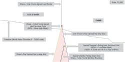
Having found that delimitation of the area of overlapping claims could be satisfactorily accomplished by constructing a provisional equidistance line, the Special Chamber identified a starting point and selected base points for the line that differed from those advanced by both parties. Given that the agreed border post 55 is situated some 150 m from the low-water line, the Special Chamber, guided by the parties’ coastline, fixed the starting point, referring to it as “BP55+.” It did so by extending the direction of the land boundary from border post 54 to BP55 until it reaches the low-water line.
After identifying base points by re-digitizing the relevant coastline reflected on British Admiralty Chart 1383, which dates back to the 19th century, the Special Chamber reduced the resulting high number of base points by using, for each party, only those points furthest from and nearest to the land boundary terminus and the points in the middle, yielding five base points for each country.13
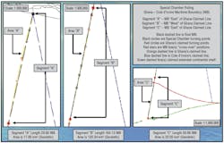
The resulting boundary, which starts from BP55+, includes six turning points at which the direction of the line changes and which are connected by geodetic lines. From the southern-most turning point, the equidistance boundary continues as a geodetic line starting at an azimuth of 191° 38’ 06.7” until it reaches the outer limits of the continental shelf beyond 200 nautical mi.14
As regards the course of the line delimiting the continental shelf beyond 200 nautical mi, which it confirmed could be fixed by it, the Special Chamber emphasized that “there is in law only a single continental shelf.”15 Without fixing a termination point, it found that this segment of the boundary runs in the same direction as the line within 200 nautical mi.
Given that the boundary line thus fixed by the Special Chamber begins south and east of border post 55 agreed upon by both parties (i.e., commences at a new starting point) and has its own six turning points, plus its own azimuth, for the remainder of the single line, the final boundary does not coincide with the equidistance line claimed by Ghana. The final line starts out east of Ghana’s claimed line, crosses to the west (offshore) and then crosses again east nearing the 200-nautical-mile EEZ limit, before continuing to the extent of the continental shelf.
The Special Chamber rejected all of the parties’ arguments that an adjustment or shifting of the provisional equidistance line was required in the present case based on “relevant circumstances” and found instead that strict application of the equidistance method resulted in an equitable solution in this case. The Special Chamber also determined that the line constructed by it “does not lead to an inequitable result owing to a marked disproportion between the ratio of the respective coastal lengths [here, 1:2.53] and the ratio of the relevant maritime area allocated to each Party [here, 1:2.02].”16
Finally, the Special Chamber rejected, for lack of convincing evidence, all of Côte d’Ivoire’s arguments regarding Ghana’s international responsibility based on allegedly unlawful conduct by Ghana both prior and during the proceedings.17
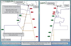
Affected offshore oil and gas blocks on either side of final boundary.
Concluding observations
Maritime boundary cases often involve, and are triggered by, competing claims to natural resources, and this case is a prime example. The Special Chamber’s ruling, which is not open to appeal, affirms the cautious treatment that international courts and tribunals generally have given to non-geographical, resource-related criteria when considering relevant circumstances that might justify adjusting or shifting a provisional equidistance line in cases where drawing such a line is feasible. According to the Special Chamber, “a de facto line or modus vivendi related to oil practice [of the disputing coastal States] cannot per se be a relevant circumstance” in maritime delimitation.18 The ruling effectively denies the equitable access to the resources of the Tano basin in the disputed maritime area that Côte d’Ivoire had sought.
By unilaterally instituting proceedings against Côte d’Ivoire in September 2014, only a few months after the two countries had agreed on the terminus of their common land boundary – an apparent “trigger” for this case – and following six years of bilateral negotiations, Ghana took a gamble, which this ruling shows ultimately paid off.
This ruling highlights that maritime boundary delimitation involves a mixture of law and science. The Special Chamber’s choice of chart BA 1383 – reflecting very old near-shore mapping that only shows the coastal low-water line in some places (and none in near general proximity to the relevant coastal frontages where all scientific law of the sea baseline analysis was needing to be conducted) and falling short of the United Nations scale guidelines19 – apparently stems from the fact that both countries had relied on that chart until 2014 and had not jointly surveyed their coasts.20 The boundary’s starting-point (BP55+) resulting from the use of this chart sits 159.87 m (geodetic) south and 18.43 m east of the parties’ agreed land terminus point (BP55), thereby favoring Côte d’Ivoire near-shore. The fact that this new position differs from the bilaterally agreed upon starting point means that the boundary line fixed by the Special Chamber nowhere coincides with the lines claimed by Ghana and Côte d’Ivoire.
While the Special Chamber’s chosen starting point of the maritime boundary might favor Côte d’Ivoire near-shore along an initial segment measuring approximately 30 nautical miles, Ghana received a final boundary that is even more favorable than the boundary claimed by it in its final submissions along a segment of approximately 164 nautical mi. The boundary fixed by the Special Chamber is actually seen to be subdivided into three segments, with the final line initially lying east, then west and again east of Ghana’s claimed equidistance line in the deepest waters as it approaches its approximate termination point at the outer portion of Ghana’s extended continental shelf (ECS) claim, which was recently accepted by the CLCS.
The maritime boundary resulting from the Special Chamber’s ruling will require adjustments, however minor, to practically all existing blocks for mineral resource activities licensed by the parties along the adjudicated boundary. This is a direct result of the Special Chamber’s line not coinciding at any point with the parties’ claimed lines. Therefore, the ruling, while binding only for Ghana and Côte d’Ivoire, directly impacts oil companies holding offshore oil and gas blocks in the hitherto disputed area.
The Special Chamber’s ruling is especially instructive regarding the legal obligations of neighboring coastal states with active offshore oil blocks but lacking an agreed maritime boundary or a provisional arrangement for joint exploration and exploitation of natural resources pending agreement on the common boundary. The Special Chamber pointed out that Côte d’Ivoire never requested Ghana to enter into provisional arrangements; hence, Côte d’Ivoire was barred from claiming that Ghana had violated its obligations to negotiate on such arrangements.21 This means that disputing states are well-advised to explore such provisional arrangements.
Following this latest ruling, the first between African coastal states in 15 years, some 70% of Africa’s blue frontiers (lake and ocean boundaries), including various in the Gulf of Guinea, are still to be delimited. This affects practically all of Africa’s maritime waters, which hold offshore hydrocarbon reserves (EEZ and ECS waters) of approximately 95 Bboe discovered, and, most importantly, yet-to-be-found reserves estimated at 70-80 Bboe, subject to basin limits.22 Many of these areas, which are believed to harbor more than half of Africa’s total reserves, are in near proximity to the present-day unresolved boundaries.
It remains to be seen how this ruling will affect other maritime boundary disputes and cases, especially the pending maritime delimitation case between Somalia and Kenya in which the ICJ will be issuing its decision in the near future. Significantly, Judge Ronny Abraham of France, who is serving as ICJ President, was a member of the Special Chamber that imposed a strict-equidistance boundary on Ghana and Côte d’Ivoire, the country that had appointed him.23 If he belongs to the majority, President Abraham normally will be a member of the three-member committee drafting the ICJ’s judgment in the case between Somalia and Kenya.
In connection with its request to be provided with the parties’ written pleadings and documents, Benin stated that “the view adopted by the Special Chamber on the delimitation of the Ivoiro-Ghanaian maritime boundary is likely to have an influence on the delimitation of the maritime areas of the sub-region, including that of Benin.”24 However, the Special Chamber pointed out that “its Judgment is binding only upon Ghana and Côte d’Ivoire [and] is without prejudice to the rights and interests of third parties,”25 which includes neighboring countries.
While the first and only maritime boundary case adjudicated by ITLOS, fixing a single boundary representing an adjusted equidistance line in the EEZs and continental shelves appertaining to Bangladesh and Myanmar, respectively, lasted only 27 months, it took the ITLOS Special Chamber just under 33 months to reach its decision. This compares favorably with the average of 69 months that maritime delimitation cases before the ICJ have taken since 1969. Other tribunals thus are emerging as a speedier alternative to the ICJ in maritime delimitation cases.
The authors
ProfessorPieter Bekker, LL.M. (Harvard), Ph.D. (Leiden) holds the Chair in International Law at the University of Dundee’s Centre for Energy, Petroleum and Mineral Law and Policy (CEPMLP), where he is Founding Director of the Dundee Ocean and Lake Frontiers Institute and Neutrals (DOLFIN). A Dutch national, he is also a Partner at CMS Cameron McKenna Nabarro Olswang LLP, the UK law firm. A former staff lawyer in the ICJ Registry and member of the New York Bar, Dr. Bekker has appeared as counsel in numerous cases before international courts and tribunals, including the ICJ and ITLOS.
Robert van de Poll, B.Sc. (Earth Sciences), M.Sc.Eng. (Geodesy & Geomatics), is Global Manager Law of the Sea for Fugro Group, one of the world’s largest surveying and engineering companies headquartered in The Netherlands, and he is also the creator of CARIS LOTS, the leading Law of the Sea and maritime boundary software used by the United Nations and by international courts and tribunals. A Canadian national, he also serves as Geology Director of DOLFIN and as a CEPMLP Honorary Lecturer.
References
1. Case concerning delimitation of the maritime boundary between Ghana and Côte d’Ivoire in the Atlantic Ocean (Ghana/Côte d’Ivoire), Judgment, 23 Sept. 2017, available at https://www.itlos.org/fileadmin/itlos/documents/cases/case_no.23_merits/C23_Judgment_23.09.2017_orig.pdf [hereinafter: Judgment].
2. An equidistance line is a line every point of which is equidistant from the nearest points on the baselines from which the breadth of the territorial sea and other maritime zones of each coastal State is measured.
3. The CLCS is an UNCLOS body charged with making recommendations to coastal States on matters relating to the establishment of the outer limits of the continental shelf beyond 200 nautical miles, without prejudice to the delimitation (i.e., fixing the course of the lateral limits) of maritime boundaries. See UNCLOS, Art. 76 and Annex II. This was the first maritime boundary case in which one of the parties (Ghana) had already received and accepted recommendations on the outer limits of its continental shelf from the CLCS.
4. The other members of the Special Chamber were former ITLOS President Thomas Mensah of Ghana (appointed by Ghana), Ronny Abraham of France (appointed by Côte d’Ivoire) and ITLOS Judges Rüdiger Wolfrum of Germany and Jin-Hyun Paik of the Republic of Korea. Judge Paik was elected ITLOS President nine days after this ruling.
5. The case was entered as Case No. 23 on the list of cases maintained on the ITLOS Web site, www.itlos.org.
6. While Ghana had described the dispute as one “concerning the delimitation of its maritime boundary with Côte d’Ivoire” in its Notice of Arbitration, and while the Special Agreement by which the parties had transferred the case to the Special Chamber referred to “the delimitation of [the] maritime boundary in the Atlantic Ocean” between Ghana and Côte d’Ivoire, during the second round of written pleadings Ghana started speaking of the “demarcation” of the boundary that it alleged had already been delimited by the parties. According to the International Court of Justice, “’demarcation’ … presupposes the prior delimitation – in other words definition – of the frontier.”Territorial Dispute (Libyan Arab Jamahiriya/Chad), Judgment, I.C.J. Reports 1994, p. 6, at 28, para. 56.
7. As used in this analysis, “azimuth” means “the bearing of a geographical position, measured clockwise from north through 360 degrees.” Report of the Law of the Sea Committee, George K. Walker, “Defining Terms in the 1982 Law of the Sea Convention III: Analysis of Selected IHOECDIS Glossary and Other Terms (Dec. 12, 2003 Initial Draft, Revision 1),” PROCEEDINGS OF THE AMERICAN BRANCH OF THE INTERNATIONAL LAW ASSOCIATION 2003-2004, p. 187, at 214.
8. As the International Court of Justice has observed, “[t[he bisector method ... seeks to approximate the relevant coastal relationships, but does so on the basis of the macro-geography of a coastline as represented by a line drawn between two points on the coast.”Territorial and Maritime Boundary between Nicaragua and Honduras in the Caribbean Sea (Nicaragua v. Honduras), I.C.J. Reports 2007, p. 659, at 747, para. 289.
9. See Articles 74 and 83 of UNCLOS (“the delimitation … between States with opposite or adjacent coasts shall be effected by agreement on the basis of international law, …, in order to achieve an equitable solution.”).
10. Judgment, para. 16.
11. Id., para. 586.
12. See id., para 360.
13. British Admiralty,Chart 1383, titled “Lagune Aby to Tema,” scale 1:350,000, published 1 July 2004 (Latest Edition date: 15 June 2017). This chart contains no low-water line information in general proximity to the Land Terminus Point to be used by both coastal States in constructing the maritime boundary. The coastline that is relevant was in fact last surveyed between 1837 and 1846. The coastline as depicted on this nautical chart lacks any precision when compared to modern-day satellite imagery.
14. Judgment, paras. 399-401.
15. Id., para. 490. See also id., paras. 373, 526.
16. Id., para. 533.
17. Id., paras. 541-656.
18. Id., para. 477.
19. See “Baselines: An Examination of the Relevant Provisions of the United Nations Convention on the Law of the Sea,” Ch. I.A., Art. 5, sub (8), (“It is recommended that in general the scale should be within the range 1:50,000 to 1:200,000”), Art. 5, sub (10) (“ … States … will usually select the low-water line shown on existing charts” (emphasis added)), UN Doc. E.88.V*.
20. See Judgment, para. 342.
21. See id., para. 628.
22. See Robert van de Poll & David Bishopp, “Unlocking Trapped Subsurface Resource Value in Disputed African Maritime Boundaries,” presentation delivered at the 21st Africa Oil Week/Africa Upstream conference, Cape Town, November 2014, available from the DOLFIN Web page, www.dundee.ac.uk/cepmlp/research/researchinstitute-dolfin/.
23. Judge Abraham also voted in favour of a strict-equidistance finishing segment of the maritime boundary inMaritime Dispute (Peru v. Chile) (ICJ Judgment of 27 Jan. 2014, I.C.J. Reports 2014, p. 3), in which advocates for Côte d’Ivoire had argued for strict equidistance on behalf of Peru. The same advocates had argued, unsuccessfully, in favour of strict equidistance in Delimitation of the maritime boundary in the Bay of Bengal (Bangladesh v. Myanmar) (ITLOS Judgment of 14 March 2012, ITLOS Reports 2012, p. 4) before a tribunal including Thomas Mensah, the Judge ad hocappointed by Ghana.
24. Letter from the Minister for Foreign Affairs of the Republic of Benin to ITLOS, 28 Sept. 2016, Rejoinder of Côte d’Ivoire, Vol. III, Annex 187, text available at www.itlos.org.
25. Judgment, para. 323.