GEOSCIENCES
Industry reacts to guidance on marine mammal impact
Multiple industry organizations teamed up to respond to the most recent draft of the US National Marine Fisheries Service’s (NMFS) guidance regarding the effects of certain sounds on marine mammal hearing.
The International Association of Geophysical Contractors, the National Ocean Industries Association, the American Petroleum Institute, and the Alaska Oil & Gas Association jointly submitted their comments to the chief of the NMFS’ Marine Mammal and Sea Turtle Conservation Division.
These guidelines will be used by federal agencies, industry, and others conducting activities that generate underwater noise, such as military testing and oil and gas exploration, the US National Oceanic and Atmospheric Administration’s (NOAA) Fisheries service said. The administration pointed to noise created by seismic airguns as one of the activities with the greatest potential to affect marine mammals.
“NOAA’s proposed changes are substantial, significant, and result in very different criteria than were proposed in the 2015 version of the draft guidance,” the associations said.
Among their comments, the groups said that the proposed changes are “incompletely documented and insufficiently explained.” They took particular issue with proposed changes to low-frequency cetaceans, saying that they are “arbitrary and contrary to the best available science.”
Malaysia multi-client program tendered
A consortium comprising of PGS, TGS, and Schlumberger WesternGeco have successfully won the tender for the rights to undertake a multi-client seismic program offshore Sabah.
The partners said that this was made possible through a new initiative by Malaysian national Petronas to stimulate offshore exploration and production investment activity. As a result, the operator, through Malaysia Petroleum Management, decided to open this area’s waters to the multi-client model for the first time.
Offshore Sabah sits in an active fold-and-thrust province that hosts a number of proven hydrocarbon accumulations, the partners said. An extension of the Brunei Baram Delta play, the primary exploration target has been Miocene deltaics with some younger Pliocene. With exploration and drilling progressing into deeper frontier waters, there is potential for new plays in the carbonate and syn-rift section. This large basin will benefit from modern, high resolution broadband 3D seismic necessary to understand both the existing play concepts and new potential plays.
The consortium is planning to apply a combination of their technology and solutions.
BGS provides expertise
The British Geological Society (BGS) will serve as technical adviser to the Isle of Man government for development of the island’s offshore energy strategy. This could lead to further licensing opportunities in the Irish Sea, it said.
Dr. Ken Milne, director of Energy and Support Services at the Department of Economic Development, said: “During the 1990s, the Isle of Man government issued several prospecting licenses to petroleum companies. Data collected from the previous prospecting studies has been re-analyzed and would indicate the presence of gas deposits. With improvements in technology it is possible that gas deposits in Isle of Man territorial seas may now be economically viable to extract.”
Ramform Tethys embarks on first survey
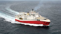
Weeks after it unveiled the name of its latest Ramform Titan-class vessel,Ramform Tethys, PGS announced plans to send the vessel to the Norwegian Sea to acquire a new 4,400-sq km (1,698-sq mi) 3D GeoStreamer survey over the Aasta Hansteen area in May.
Ramform Tethys will deploy a deep-tow acquisition configuration of 16 streamers with 75 m (246 ft) separation.
The prefunded multi-client project is situated on the Nyk High in the outer Vøring area. It will address imaging challenges caused by deepwater and structurally complex geology, due to several episodes of rifting, compression and subsidence, PGS said, and noted that the dataset could be used as a baseline survey for future 4D studies.
Work is planned to be completed in August, PGS said, and fasttrack data will be available four months after the final shot.
Ramford Tethys’ design is said to adapt advanced maritime technology to the imaging capabilities of the company’s GeoStreamer seismic acquisition technology. The 70-m (229-ft) broad stern is said to be fully exploited with 24 streamer reels: 16 aligned abreast and eight reels further forward, with capacity for 12-km (7.5-mi) streamers on each reel.
WGP expands services
Thalassa Holdings has issued an update in the reservoir monitoring programs offshore Norway of its subsidiary WGP Exploration. Design improvements to the company’s dual portable modular source system (D-PMSS) during the 2014-15 winter maintenance period helped WGP to deliver four successful permanent reservoir monitoring (PRM) surveys, it said.
The company acquired more than 6,000 km (3,728 mi) of data last spring for Statoil over the Snorre and Grane fields, on time and with better-than-expected technical downtime levels. Although Statoil reduced last fall’s surveys to a total of just under 4,000 km (2,485 mi), downtime levels improved for the two surveys completed at the end of October. The system was then demobilized to WGP’s storage facility onshore for the first of a two-stage maintenance program before the spring 2016 start-up took place.
Last April, WGP secured a contract to acquire high resolution 3D (HR3D) P-Cable seismic in the Barents Sea for TGS Nopec Geophysical. This was a follow-on project from multi-client operations performed in 2014, and also deployed the vesselBergen Surveyor.
Operations started early last May. The program comprised extended regional coverage with high-resolution single swath 3D (HRSS3D) data acquisition, combined with targeted HR3D blocks. This season’s targets are to acquire speculative HR2D data for TGS in new blocks, and to provide an insight into the potential of both P-Cable data and also shallow target resolution in previously identified focus areas.
WGP’s improvements in its handling systems, navigation, 3D binning, and in-water towing geometry led to better than expected results in terms of acquisition efficiencies. The company is optimistic about future prospects for HR3D/HRSS3D and plans to further improve its suite of systems.


