Reprocessed survey reveals potential play in the Bonaparte basin

Broadband 3D seismic provides clearer picture of hydrocarbon viability
Paolo Esestime, Karyna Rodriguez, David Eastwell
Spectrum Geo Ltd.
The Paleogene and Neogene intervals are poorly documented and largely overlooked from the hydrocarbon exploration in the North West Shelf (NWS) ofAustralia. However, there are indications of viable play in certain stratigraphic levels. In the Bonaparte basin, for example, the Pituri 1 well encountered minor oil within the Eocene Grebe Sandstone, and minor fluorescence was observed in basal Miocene cuttings in the Pollard 1 well.
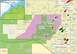
In 2015,Spectrum’s Cartier-Main 3D multiclient seismic survey was reprocessed through a broadband workflow that included effective de-ghosting techniques and pre-stack time and depth migrations, achieving an extremely significant imaging uplift. The survey covers around 2,800 sq km (1,081 sq mi) on the eastern side of the Ashmore Platform between the Browse and Bonaparte basins. The reprocessing enhanced structural and stratigraphic elements at different levels, such as deep Permian carbonate build-ups and Triassic horst blocks. In the overburden section, the stratigraphic detail of the Paleogene and Neogene sections has allowed a deeper understanding of their evolution through time.
Regional setting
In Australia’s NWS, source rocks have been deposited throughout various rifting events since the Late Devonian and during the Early Carboniferous and Early Permian.
Proven reservoirs extend from Permian shallow-water carbonates to Triassic-Jurassic sands, the latter deposited during a transgressive event, after a phase of uplift and inversion which was active mainly during the Early Triassic.
In the Ashmore Platform, Triassic tectonism resulted in a sedimentary hiatus and a regional unconformity, overlain by Jurassic siliciclastic units, and discontinuously distributed lagoonal successions, which are mostly the expression of continental environments.
Subsidence was re-established at the end of the Jurassic and during the Cretaceous, accompanied by moderate tensile tectonics. As a consequence, a regional transgression allowed the siliciclastic to be deposited in nearshore deltas, characterized by initial fine-grained facies, and gradually passing up into coarser intervals and shallow-water limestones, as marine conditions returned. The Late Cretaceous sediments include the lowstand basin floor fans of the Puffin formation, which is the most prolific hydrocarbon target currently explored.
By the end of the Cretaceous, sediment supply became more complex, connecting basins with similar bathymetric conditions and different depositional environments. Carbonate development was extensive in areas with restricted clastic inputs in both the Bonaparte and Browse basins.
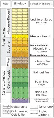
Several depositional sequences can be distinguished in the Paleocene, Eocene, and Miocene and encountered in a number of wells along the eastern margin of the Ashmore Platform, including Keeling-1, Woodbine-1, and Gryphea-1. These sequences usually start with siliciclastic intervals, overlain by calcarenites and fine-grained limestones. The limestones are deposited during highstand periods, when pelagic or distal conditions become widespread; the clastic deltas are forced to prograde laterally in response to base level fall during lowstand phases (Eocene Grebe and Miocene Oliver sandstone formations).
Seismic mapping
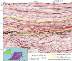
Seismic interpretation over the Cartier 3D has been performed in the pre-stack time migration domain. The main objective was to recognize syn-sedimentary features related to the Paleocene, Eocene, and Miocene intervals, all of which have been calibrated through time-depth curves available for the Keeling-1 well.
Picking the main sequence boundaries allowed seismic facies analysis between the intervals, largely supported by spectral decomposition and the red green blue (RGB) color blend display. Several volumes have been extracted for incremental frequency bands, and output as envelope of the amplitude at each frequency slice, finally combined in an RGB image.
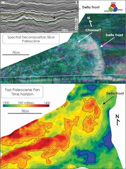
An evident sedimentary wedge can be identified at the base of the Paleocene in the southeast portion of the 3D. Detailed mapping highlighted various structural/stratigraphic closures and a lateral geometry compatible with a distal fan-delta. The spectral decomposition confirmed the position of a delta front which originated from southwest; the body appears mostly massive and channeling can only be slightly distinguished.
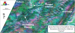
A number of frequency slices have been created within the siliciclastic Eocene interval (Hibernia formation); these indicate a prograding pattern from northwest to southeast. An interpreted platform can be correlated with the Eocene shape of the Ashmore Platform, which was probably uplifted and acted as source for the sedimentary pulses. Meandering and braided channels are clear in the upper portion of this interval, within the platform area, suggesting an estuarine setting.
Channels are evident in the siliciclastic interval at the base of the Miocene, possibly related to the Oliver sandstone formation. The color blend allows identification of the different domains which form the fan-delta, from main linear channels to dendritic and meandering patterns, these are concentrated in the south, suggesting a sediment supply mainly oriented from northwest to southeast.
Conclusion
Through the use of broadband 3D seismic, Spectrum has performed a regional facies reconnaissance study over the Paleogene and Neogene sequences to support the viability for hydrocarbon exploration of Cenozoic plays in the Browse and Bonaparte basins.
The Paleocene fan-delta shows a mixed character of mass transport and limited channeling, with a clear provenance from SW and a distal marine environment.
The Eocene and younger sections show patterns and facies that can be correlated to a dynamic bathymetric evolution, with mostly shallowing upward sequences and coastal areas probably affected by uplift and the temporary development of continental conditions. Clastic input mainly resulted from base level fall and subsequent lowstand periods. Seismic evidence indicates the sediment was supplied from the main continental shelf and the Ashmore Platform.
Cenozoic reservoir sections have been encountered in a number of wells in the Bonaparte basin with potential traps revealed by spectral decomposition from high-quality 3D seismic data.