Electromagnetic Geoservices ASA has received a $2.7-million contract to supply 3D EM data acquisition in the Barents Sea to OMV (Norge) AS and its partners in PL537. The survey will commence in July using the vessel Atlantic Guardian.
TGS has two multi-client geochemical seafloor sampling and seep studies offshore Canada and in the Barents Sea. Sampling locations for both programs were identified using recently acquired multi-client seismic data.
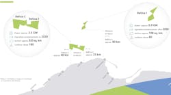
The Labrador Sea Sampling 2014 will be collected in partnership withVBPR and PGS, and is a multi-client geochemical seafloor sampling and hydrocarbon seep study offshore Newfoundland and Labrador, Canada. The project will provide data along the 1,200 km (745 mi) long Newfoundland-Labrador coastline with its seep anomalies on the seafloor. In addition to the seep samples, TGS will acquire heat flow measurements to constrain basin models.
The Barents Sea Sampling 2014 will be acquired in partnership with VBPR and focuses on blocks within the Norwegian 23rd licensing round, specifically in the greater Hoop area and in the newly opened southeast Barents Sea. The work will cover multi-client geochemical seafloor sampling and seep studies plus stratigraphic sampling.
The scarcity of well data in the central Barents Sea makes stratigraphic sampling of the reservoir section key for exploration in the area. All hydrocarbon seep samples will be collected using the gravity coring and the results are expected to provide information on the depositional environment, maturation, and age of the hydrocarbon source.
Data acquisition will commence during 3Q 2014 and initial data is scheduled to be available to clients in 2Q 2015. The projects are supported by industry funding.
TGS also has acquisition of Snipe Phase 52, a new long-offset 2D multi-client survey in the ultra-deepwater US central Gulf of Mexico. The survey will include 12,000 km (7,456 mi) of data.
"The new project will provide long-offset, high-resolution data required to image potential reservoirs in the lower Tertiary and deeper, as our understanding of the basin and depositional processes continues to evolve," said Rod Starr, SVP Western Hemisphere for TGS. "The Snipe Phase 52 program will extend to the US-Mexico international boundary and will complement TGS' previously announced plans to acquire 2D data in the southern Gulf of Mexico waters, pending permits from the Mexican authorities."
The seismic data will be acquired by theM/V Osprey Explorer towing 12,000 m (39,360 ft) cable length. The project will commence in 3Q of this year and final data will be available to clients in 4Q 2015. The survey is supported by industry funding.
TGS andFairfieldNodal have executed a multi-year collaboration agreement to develop, plan, and execute multi-client Full Azimuth Nodal seismic surveys in the US Gulf of Mexico shelf region. The project will combine FairfieldNodal's Ocean Bottom Node Z700 technology with TGS' imaging solutions.
PEMEX recently awarded CGG a contract worth about $200 million for ocean bottom cable 3D-4C seismic work in the Ku Maloob Zaap oil field and the light crude oil fields of the Bay of Campeche in the Gulf of Mexico. The acquisition will be conducted by Seabed Geosolutions – the joint venture that CGG and Fugro incorporated in early 2013 to handle all seabed-related seismic acquisitions. CGG will be processing all in-field data for Pemex. Operations are under way and expected to be finalized in 3Q 2015.
Displaying 1/2 Page 1,2, Next>
View Article as Single page