GeoSphere service enables operators to more precisely land wells, steer and map the reservoir
Gokhan Yarim
Schlumberger
Today's market realities pose a unique challenge for the oil and gas industry: how to meet growing global demand for hydrocarbons that are increasingly hard to find and produce. The paradox has raised the stakes for operating companies to fully understand what lies miles beneath the surface – how the formation is structured, where the productive zones are located and how best to produce those otherwise hidden hydrocarbons that can no longer be left behind.
Over the years, breakthroughs in logging-while-drilling (LWD) technology have expanded the industry's ability to understand the reservoir, providing critical measurements for determining formation properties, beginning with simple imagery techniques and resistivity logs, then advancing to more sophisticated logging tools that have traditionally focused on near-wellbore measurements. To obtain deeper measurements, operators have relied on surface and downhole seismic tools to provide insight into the formation in order to target the productive zones.
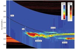
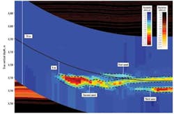
The capabilities of LWD technology have been expanded with the first-ever reservoir mapping-while-drilling technique that uses real-time deep, directional electromagnetic measurements to reveal subsurface beddings, fluid boundaries and multiple formation layers. The GeoSphere reservoir mapping-while-drilling service enables drillers to more precisely land wells, and steer and map the reservoir with a deeper range of investigation than ever before that extends more than 100 ft (30 m) from the wellbore.
This greater control of wellbore trajectories can help develop completion strategies to optimize horizontal sections when drilling into productive zones. Enhanced understanding of reservoir thicknesses ensures optimum placement of the wellbore in the most productive sands, away from water-bearing formations and close to the top of the reservoir section, resulting in increased reservoir exposure and net pay with minimum water production. Furthermore, the expanded, real-time view of the reservoir allows companies to strategically drill and land wells, reducing the associated risk and cost.
The system, which detects formation boundaries, can map oil/water and oil/gas contacts, enabling better real-time decisions related to reserves and ultimate recovery, and also navigate compartmentalized and complex reservoirs to fully understand the different structures. By improving production rates and minimizing water production, the service reduces risk and cost to optimize wellbore economics.
Data provided by the GeoSphere service can be integrated in real time with other downhole measurements and used to update geological reservoir models and refine existing seismic models to further analyze the field.
Based on electromagnetic technology, the system uses downhole transmitter and multiple receivers to send signals in different frequencies to detect multiple formation boundaries, fluid layers and geological structures in 3D using novel mathematical inversion techniques combined with high-power computing.
The reservoir mapping-while-drilling service has been successfully deployed in more than 150 wellbores globally. Brazilian operator Petrobras has used the technology to accurately land three multiple-target wells in thin channel sands in offshore Brazil without drilling pilot holes. Reservoir data based on seismic measurements was uncertain. The reservoir mapping-while-drilling service remotely detected reservoir markers, including a structural dip and depth distribution of the layers, and mapped contrasting layers and shale thicknesses to identify the sweet spot. The real-time depth of investigation data enabled the operator to drill through the sand bodies to land all three wells in the main reservoir below, adjusting the trajectories of two of the wells for more precise landing.
As the industry ventures into increasingly challenging areas, breakthrough technologies such as the GeoSphere reservoir mapping-while-drilling service provide a deeper understanding of the subsurface structures, formation thicknesses and fluid boundaries.
In a market environment where hard-to-find assets can no longer be left behind, this technology can reveal formation characteristics to expand operators' ability to land, steer and map reservoirs, opens up new opportunities for optimizing recovery and reducing costs and risk in the most complex formations.
The author
Gokhan Yarim is vice president, Marketing and Technique, Drilling & Measurements, Schlumberger.

