Brazil's equatorial margin offers new frontier

Multi-basin area presents more challenges than the pre-salt, says Petrobras E&P director
Peter Howard Wertheim
Contributing Editor
In an exclusive interview withOffshore, Guilherme Estrella, Petrobras E&P director, recently explained why the Brazilian equatorial margin, the new exploratory frontier where the company is preparing to invest heavily, presents challenges that are even more interesting and defying than the discovery of oil in the South Atlantic pre-salt layers.

The equatorial margin is formed by the Foz do Amazonas (mouth of the Amazon River), Pará-Maranhão, Barreirinhas, Ceará, and Potiguar (offshore) basins on the northeast coast of Brazil.
“The existence of a dynamic petroleum system which generated, migrated, and accumulated oil in the equatorial margin is already proven,” said the director. “We have samples of extremely light oil from the PAS-11 block, Pará submarine 11, collected from a well drilled in 1983. During three months we produced oil and gathered concrete evidence of a petroleum system. But the great challenge is to interpret the geology of the area in order to choose places to drill with the probability of discovering natural gas and/or oil in commercial quantities and which can be produced in an economically viable manner.”
There are fewer than 30 blocks under concession in the deepwaters of the equatorial margin, and according to the National Petroleum, Natural Gas and Biofuels Agency (ANP), in the last four years a little more than five wells were drilled and no more than nine seismic surveys undertaken. ANP will offer the 11th bidding round in late September or October this year. Out of nine basins included in the auction, five are located in the equatorial margin.
The Foz do Amazonas basin is situated at the western portion of the equatorial margin, alongside the coast of the Amapá and Pará states. It occupies an area of approximately 261,170 sq km (100,838 sq mi), including the continental platform, slope, and deepwater region, to the boundary between continental and oceanic crust.
Estrella explained that the cycles of exploration at the mouth of the Amazon River are related to the renewed interpretation of data and an increased knowledge that leads to new alternatives in the identification of commercial opportunities. These are the main reasons why Petrobras is now returning to that area.
For example, China's Sinopec teamed with Petrobras in April to develop offshore areas of the Pará-Maranhão basin. In June, Petrobras informed the ANP of the discovery of traces of oil and gas after drilling a 2,060 m (6,759 ft) well in the deep waters of the BM-PAMA-3 block (833.28 sq km or 321.7 sq mi). The accord also includes exploration under the BM-PAMA-8 concession contract which includes three blocks totaling 2,307 sq km (891 sq mi).
The Pará-Maranhão basin is offshore Pará and Maranhão states. At present there are 13 offshore blocks under concession, all in the exploratory phase, totaling 4,871 sq km (1,881 sq mi). The companies operating in the area are: Petrobras; Petrobras in association with Ecopetrol and Vale; and OGX.
“The equatorial margin's coastal geology is much less known than the geology of the South Atlantic basins, especially due to interpretation difficulties caused by shear faults that resulted in a far more complex model for these sedimentary basins, Estrella pointed out. “When separating from the African continent, the movements at the South Atlantic coast were more of distention and not of dragging of one over the other. This created a very complex situation and is still interfering in the definition of the dynamics of the region's petroleum system, even after producing in the PAS-11 block.”
He also explained: “The prospectivity is considered high because we already identified a generation module of oil and gas, the source rock, the migration to a reservoir rock, and the trapping. We should also say that in the same latitude, on the African side, production is having success in Nigeria, in Ghana with the Jubilee discovery, offshore Ivory Coast, and in Equatorial Guinea, thus confirming the potential of the region.”
The type of oil discovered in these basins offshore West Africa is very light, 44º API. Jubilee holds reserves estimated at 1.8 Bbbl of oil; and Tweneboa/Owo/Ntomme, in Ghana, is estimated at 1.4 Bbbl.
“However, the situation in the Amazon River delta is completely different than what happens in the Niger River delta in Nigeria. The Niger has a much smaller load of sediments and its drainage basin discharges through a massive delta to the Gulf of Guinea, which is sheltered. That gulf does not have as much circulation at the bottom as the Amazon River delta, thus preserving the organic material in deposition,” he added. “The Amazon River cone, as it is known, is not matched anywhere in the world and is the largest in terms of sedimentary load,” Estrella continued. “The river loses only to the Nile in terms of extension, but in terms of deposition of mud, sand, and sediments it has by far a much larger load than other great rivers, including the Nile. When such a large load of sediments originated from land arrives at the mouth of the river, the fresh water, well oxygenated, mixes with organic material which is quickly oxidized and destroyed.”
He also noted another difference: “With the rotation of the Earth, the surface maritime currents run from east to west. These currents run in the opposite direction from the Earth's rotation, creating an interesting phenomenon: at the Brazilian coast, as in all oriental coasts of the continents, the surface maritime currents pressure surface waters offshore these continents because they push these waters. The surface currents coming from West Africa to Latin America leave behind, on the surface, a sub-pressure; and because the pressure is lower, it creates a phenomenon called ‘upwelling'.”
The cold waters of the bottom rise and these currents from the bottom are highly loaded with organic nutrients. That is why the oriental coasts of the continents are richer in fish than the western coasts, such as in Brazil. Through geological time, nutrients and organic material were deposited and eventually formed petroleum source rocks.
For this reason, in Nigeria a great share of the petroleum is of marine origin and is in the post-salt, rather than source rocks of lacustrine origin such as can be found in Brazil's pre-salt. However, Africa also has petroleum from lacustrine origin because Africa, together with South America, was once one continent, around 130 million years ago, before the continental rift occurred.
Around 11 million years ago, the Amazon River originated as a transcontinental river and took its present shape approximately 2.4 million years ago. These are the most significant results of the study on two boreholes drilled near the mouth of the Amazon River by a team from Petrobras, the Institute for Biodiversity and Ecosystem Dynamics (IBED) of the University of Amsterdam, and of the University of Liverpool (UK).
Before, scientific drilling expeditions such as the Ocean Drilling Program could only reach a fraction of a sediment column around 10 km (6 mi) thick from the Amazon deep-sea fan (a sort of underwater delta). New exploration efforts by Petrobras plus sedimentological and paleontological analysis on samples from the two boreholes (one of which was 4.5 km [about three miles] below the sea floor), gave deep insight into the history of both the Amazon River and the Amazon deep-sea fan. This data was published in the scientific journal Geology in July 2009, and is very important to understand South America's paleogeography and the evolution of aquatic organisms in Amazonia and the Atlantic coast.
More recently, the basin was the target for a 2D spec seismic survey. According to the ANP, since the 1980s, 93 exploration wells have been drilled in the basin, 60 by Petrobras and 33 by companies within risk contracts. This exploration effort resulted in the discovery of two sub-commercial gas accumulations: Pirapema and the area of well APS-51A.
Currently, Petrobras has 100% interest in two blocks in the exploration phase (FZA-M-217 and FZA-M-252) at Foz do Amazonas basin totaling approximately 38,000 sq km (14,672 sq mi).
Technical hurdles may be quite simply described by a geologist such as Estrella, who has been involved in the discovery of huge amounts of oil worldwide. “To exemplify the challenge that we face in the mouth of the Amazon River, one needs to address a curious characteristic that is technically complex: the surface currents running towards the north by the coast of Amapá state are so strong that pollen from the Amazon forest plants were identified in British beaches, carried by the Gulf Stream current. For this reason, in order to place a blow out preventer at the bottom of the ocean to begin drilling at 1,000 m (3,280 ft) water depth, we have to move the snubbing rig dozens of kilometers against the current, before starting to lower the BOP to land it where it was planned. Of course, lighter equipment has to be released even further away. In the case of the rig, dozens of kilometers is just an example, but the distance must be calculated according to the weight of the equipment.”
Further to the east, after Pará-Maranhão basin, the Barreirinhas basin is found offshore starting north of the Parnaíba River mouth, border of Piaui state, ending northwest of São Luís, the capital of Maranhão state. Although there have been no significant oil discoveries, the occurrence of hydrocarbons traces in several wells that were drilled leads to the expectation of light oil and condensates, says the ANP. There are four blocks under concession in the exploration phase totaling 3,268 sq km (1,262 sq mi). In two contracts, Petrobras has 100% interest; it has partnerships with international operators in the others.
According to Estrella, “Barreirinha is an onshore basin which has an extension offshore. There were non--commercial discoveries onshore but the offshore part is more or less related to PAS-11, discovered in Pará-Maranhão basin. We believe that both are part of the same petroleum system.”
Further east, Ceará basin has four offshore petroleum producing fields: Xaréu (1977), Curimã (1978), Espada (1978), and Atum (1979). Early estimates for these fields are of 71.8 MM cu m (451.6 MMbbl) of oil and 5.8 MM cu m (204 MMcf) of gas. Besides these fields Petrobras has two exploration blocks totaling 1,216 sq km (470 sq mi) with dozens of well drilled and numerous traces of oil and gas.
Potiguar basin is in the extreme northeast of Brazil's continental margin and includes onshore and offshore areas. Most of it spreads throughout Rio Grande do Norte state, overlapping to Ceará state. It is one of the 10 oil and gas producing basins in the country.
Offshore, 14 fields are either producing or are being developed; and 67 are producing onshore. Current offshore production of 44,000 b/d of oil and 12 MMcm/d (424 MMcf/d) of natural gas comes from Dentão, Pescada, Arabaiana, Biquara, West of Ubarana, Ubarana, Agulha, Cioba, Siri, Aratum, and Serra fields. The three fields being developed are Salema Branca, Guaiuba, and Guajá.
Petrobras operates two blocks in shallow waters and four in deepwaters of the Potiguar basin, totaling a 4,490 sq km (1,735 sq mi) area.
Offshore Potiguar basin, the volumes in situ are estimated at 1.18 Bbbl of oil and 60 bcm (2,118 bcf) of natural gas. Offshore proven reserves are of 105 MMbbl of oil and 8.3 bcm (293 bcf) of natural gas.
Estrella noted that “the Portiguar basin is important because very often, when oil can be produced onshore, the chances for finding oil in the basin's offshore extension are good. The opposite though, is also true, when you cannot find oil onshore it does not mean that you will not be able to find it offshore, as for example in Campos basin. It is always possible to find oil offshore, but when there is oil onshore, there is a very good chance to find it offshore as well.”
Campos basin is responsible for around 80% of Brazil's total oil output, practically all of it in the post-salt. The most significant discovery made in the pre-salt area of the Campos basin was announced June 28 by a consortium formed by Repsol, Sinopec, Statoil, and Petrobras. The 1-REPF-11A-RJS well, informally known as Gávea, yielded good quality oil, 190 km (118 mi) off the coast of Rio de Janeiro. The well was drilled by the latest-generationStena DrillmaxI drillship in 2,708 m (8,885 ft) water depth, reaching a final depth of 6,851 m (22,477 ft).
Currently, Brazil's deepwater oil production represents 25% of the country's output. Analysts say that new pre-salt provinces will increase this percentage significantly. Petrobras' enthusiasm offshore is expressed by its strategic planning which foresees 169 platforms, 504 support vessels, 53 drilling rigs, and 48 oil tankers until 2020.
“However, we have limitations,” Estrella observed, referring to the economic aspects that change the price of oil over long periods. “When planning to order a fleet of production ships for the company's projects, we depend on forecasts for the price of oil. To approve a production ship project, the forecast is part of the calculations. Well, we have no way of injecting more water in Marlim field, now that the field is producing more water and the water injection capacity installed in our ships has reached its limits. For instance, consider the hypothesis of a forecast of less than $40 per barrel in the project being planned for a field that we believe will be producing 60% of oil and 40% of water in 10 years. The ship is planned to work in that field and will be prepared to produce up to this financial limit. It is true that we depend on these forecasts. When Marlim started, we based our ship-based projects on $35 oil. But with oil around $100 per barrel, we could produce 60% water and 40% oil and it would still be worth it. But now the injection capacity of the ship is already set for the limits imposed by the other price, and this is only one example. The result is that we have to offload the excess water in other ships instead of re-injecting in the well, because the ship doesn't have the injection capacity equivalent to the water the field is currently producing.”
Compared to other operators worldwide, Petrobras has a dominant position in the demand side for offshore rigs, semisubmersibles, and drilling ships, plus a firm demand for several critical resources that are not yet contracted. The scale of future acquisitions is guaranteed by the 23 new production systems scheduled to start operating by 2014 and 36 more between 2015 and 2020.
Estrella contends that the neither the local content requirements (goods and services produced in Brazil) nor the obligation that Petrobras operate blocks in the pre-salt area that have not been previously auctioned will diminish the interest of foreign companies.
“We are an industrially diversified, competitive, and strong country with a huge market. Besides that, the pre-salt represents a spectacular amount of wealth which means utilization of resources in a large scale. We are offering unprecedented conditions for growth in the country's history. There are new companies coming to Brazil and the ones already installed here will surely expand their activities. For all of these reasons, the country will no longer play a supporting role. We are going through a geopolitical change to become one of the major players in the energy sector.”
Petrobras is seeking international partners as its production is expected to double oil production in the next 10 years to reach 4 MMb/d.
The 11th bidding round includes 174 blocks (87 are offshore and 87 are onshore), totaling 122,000 sq km (47,100 sq mi), divided into 17 sectors in nine sedimentary basins. Besides Foz do Amazonas, Pará-Maranhão Barreirinhas, Ceará and Potiguar, there will be offers in Paranaíba, Espírito Santo, Recôncavo, and Sergipe-Alagoas basins. If all blocks are auctioned, Brazil´s exploratory area will have a 40% increase.
The author
Peter Howard Wertheim is based in Rio de Janeiro.
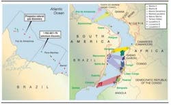
The Brazil-Africa connection
Geologists are increasingly finding that the hydrocarbon-bearing basins offshore South America are similar to those offshore West Africa. And the activity offshore West Africa is picking up.
Petrobras E&P director Guilherme Estrella says that the equatorial margin will be the next challenge for Brazil's oil and gas industry after the pre-salt, particularly because there are so many oil and gas discoveries in West Africa, and there is much geological similarity between Brazil's equatorial margin and West Africa's.
After decades of poor results in the exploration of oil and gas offshore Ghana, in 2007 Anadarko and its partners finally discovered the Jubilee field through the Mahogany-1 well. Since this well was drilled into a stratigraphic trap instead of a more easily identified structural trap, other companies also are trying to locate and map stratigraphic traps. Other important finds in Ghana are Mahogany Deep, Odum, and Tweneboa. The discovery Dzata is operated by Vanco Energy, the discovery Enyenra (Owo) is operated by Tullow, and Teak operated by Kosmos.
The Ivory Coast has the Baobab field, on block CI-40, approximately 25 km (16 mi) offshore with estimated reserves of 700 MMbbl and expects to recover 200 MMbbl. Canadian Natural Resources (CNR) is the operator (57.6% interest), in partnership with Svenska (27.4%) and Petroci (15%).
Espoir field (120 MMboe), discovered in 1982, lies in Ivory Coast block CI-26, approximately 19 km (12 mi) offshore south of Jacqueville, and around 60 km (37 ft) southwest of Abidjan. Water depths range from 100 to 600 m (328 to 1,968 ft). The Espoir field has estimated recoverable reserves of 93 MMbbl of oil and 180 Bcf of natural gas.
Well Acajou-1x was drilled by theSovereign Explorer rig. The well on the Acajou South prospect (license CI-26) is approximately 24 km (15 mi) off the coast of Côte d'Ivoire in 3,050 ft (930 m) water depth, some 9 km (5.5 mi) distant from Espoir field. The oil is 33° API, similar to that found in Espoir.
Both fields are operated by CNR (58.67%) in partnership with Tullow (21.30%) and Petroci (20%).
Côte d'Ivoire's largest natural gas producer is the Foxtrot field in offshore block CI-27. It is operated by Foxtrot International (24%) in partnership with Petroci (40%), SECI (24%), and Gaz de France (12%). The other producing Lion and Panthère fields were discovered by Phillips in the 1980s. Other discoveries in the Ivory Coast beside: Lion; Panther are Belier; Kudu; Eland, and Ibex.
Offshore Articles Archives
View Oil and Gas Articles on PennEnergy.com