Advancing the art of subsea inspection
Steve Keedwell
Shell Companies in Nigeria (SCiN)
Shallow-water autonomous underwater vehicles (AUVs) are a valuable tool for asset inspection, providing benefits for customers, operators, and contractors alike. However, the technology has not been widely used in the oil and gas industry for asset inspection in shallow water. Working together with partners, Shell Petroleum Development Co. (SPDC) has achieved several notable firsts in utilizing shallow-water AUVs offshore Nigeria, including the first survey under the hull of an operational FPSO vessel.
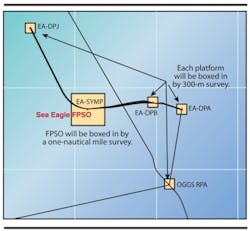
In a notable first for the industry in West Africa, SPDC, together with partners, has utilized shallow-water AUVs off the Nigerian coast to survey and inspect subsea assets. These include production systems, such as three platforms and infield pipelines/flowlines located in the EA field, theSea Eagle FPSO, as well as the Offshore Gas Gathering System (OGGS), a 260-km (~160 mi) pipeline spanning the edge of the Niger Delta.
Due to the challenging near-shore security situation, the deployment of a slow-moving traditional survey vessel towing sensors was risk-assessed as unacceptable. The assets to be surveyed are located only some 20-40 km (~12-25 mi) off the Niger Delta coastline, in water depths of 15-40 m (~50-130 ft). OGGS pipeline and EA field surveys had previously been delayed due to security concerns. In order to ensure safe offshore operations, regular surveys are required to assess the integrity of subsea assets as well as evaluate any detailed inspection or maintenance needs that may have emerged.
Shell has a track record of adapting new technology to reduce the HSSE exposure of personnel. So it came as no surprise that, with a growing need to gather data on the offshore assets, SPDC’s Geomatics Team was tasked to review alternative survey options. This led to the selection and deployment of the REMUS 100 AUV operated and managed by Fugro Survey Nigeria Ltd. (FSNL), and supported by Fugro Survey Africa (Pty) Ltd. (FSAPL).
Fugro Chance Inc., part of the Fugro group, provided two REMUS 100 (Remote Environmental Measuring Units) systems with associated equipment, with FSNL and FSAPL providing project management and personnel. SPDC provided the overall project management, in-country logistics and vessels to execute the work.
The REMUS 100 is a compact, portable, and lightweight (37 kg in air) AUV with an operating depth of 100 m (~330 ft) that can be deployed either from a vessel of opportunity or the quayside. A specially designed rake is used to launch and recover the AUV. An additional tool adapted for the project was a “dog leash” to secure the nose of the AUV and to control its entry to the rake. When safely in the rake, the AUV was manually lifted back onboard the vessel. The AUV can be fitted with a range of sensors and Inertial Navigation Systems (INS).
Immediate results
To complete the survey operations in Nigeria, two AUVs were operated simultaneously. Inspection surveys were managed from a main operations vessel that maintained a safe distance from the Niger Delta coastline. Launch and recovery of the AUVs, carried out by SPDC personnel, was undertaken by a smaller and faster vessel. Careful planning around logistics, operations, and continual risk assessment was important to minimize security risks and personnel exposure.
The ability of the AUV to survey within a few meters of platforms and facilities provided additional value. First, it avoids the HSSE exposure of the traditional survey method of vessels making close passes to structures. Second, the time to complete a 600-m (~2,000-ft) survey centred on a structure is reduced, as the AUV turns significantly faster than a vessel equipped with a standard towed array of sensors (which requires approximately 30 minutes to turn as opposed to the AUV turning time of 20 seconds). Also, the time required to mobilize the AUV on a vessel is significantly shorter than to install a survey package of a side-scan sonar and winch on a traditional vessel. Ultimately, a high-quality dataset was acquired more quickly, more safely, and at reduced cost.
Pushing boundaries
To monitor the AUV during the mission, an operational practice was established to receive iridium calls (via satellite) from the AUV, at the control center on board the operations vessel. On receiving the iridium message from the AUV, the position would be plotted and an update on the estimated time to complete the survey established.
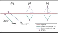
As confidence grew in the performance of the REMUS AUV, more complex missions were conducted, including combined long baseline (LBL) and “dead reckoning” missions. An LBL array uses seabed transponders placed at known locations on the seabed with baselines that can be several kilometers in length. The position of each transponder is uploaded into the AUV navigation software and, during the mission, the AUV navigates by calculating its position relative to each of the transponders, which are set to transmit when interrogated by the AUV.
The process of “dead reckoning” is used to determine the current position based upon a previously known position fix, and advancing that position based upon measuring speed over elapsed time and course deviation. The REMUS AUV is fitted with a range of sensors – Acoustic Doppler Current Profiler (ADCP), Doppler Velocity Log (DVL), conductivity, temperature and pressure sensors – and uses internal software to update its position based on the sensor inputs received for navigation. An L1 GPS antenna with iridium satellite communication, was also installed to send updates on the AUV’s health, and to derive its sea-surface position. The AUV sensor payload can be modified to include a dual high-resolution side scan sonar (900 kHz), video camera, and INS.
Using this hybrid approach, the purpose of these missions was to acquire surveys around the structures and decrease the number of infill pipeline/flowline surveys that would be required on completion of the platform surveys.
During these missions, there were a number of notable firsts:
- Utilization of a shallow water AUV in Nigeria
- Multiple platform surveys completed in Nigeria by an AUV
- Dual launch and operation of AUVs in Nigeria
- Survey under the hull of an operational FPSO in Nigeria by an AUV.
Great potential
The primary challenge was to conduct an important survey in a volatile area with many security challenges, and to do so in line with Shell’s principle of zero harm to people and the environment. The use of AUVs enabled SPDC to achieve this goal, but also to leverage technical and commercial benefits for surveying seabed assets in shelf and near-shore environments.
AUV recovery using the specially designed “rake.”
There is potential for using this method to conduct offshore surveys in high-risk locations. These include risks of security, unexploded ordnance or mine surveys, requiring a low profile and presence on the actual site. Further opportunities include environmentally sensitive areas such as coral reefs, where minimal impact is desired. The possibility of acquiring high-quality datasets with a reduced footprint is in the early stages. The surveys conducted by SPDC and partners have effectively proven the value of this method from cost, quality, and safety perspectives.
Other scenarios could include launching multiple AUVs from one survey vessel, which could also conduct survey operations. For example, during annual pipeline inspection surveys, the vessel could target pipeline crossings, leaving the AUVs to complete other tasks, and carry out passes close to structures. AUVs have also been deployed in shallow water by Shell’s Geomatics Team in the Netherlands at the Ameland platforms.
Recommendations
Opportunities to leverage benefits of shallow-water AUV operations in debris, inspection, and general seabed surveys, plus operational recommendations, include the following:
- AUVs can operate in sea conditions that would preclude standard towed system operations. Depending on water depth and prevailing weather conditions, a heave effect on side-scan sonar records could impact data quality. This would need to be assessed on a project-by-project basis.
- For deployment of AUVs from smaller vessels, a team of three to four people (depending on operational hours) is recommended to manage the AUV in the field – party chief, electronics engineer, and online surveyor (plus one if required). Good pre-planning of logistics (e.g. fueling) would enable extended field operations. It is recommended that the data be checked in the field for integrity before transfer onshore for processing. This reduces the number of personnel in the field, hence HSSE exposure.
- Launch and recovery of the AUV needs to be improved. These activities were managed by modifying the rake to contain two supporting ropes on either side. In addition, the head of the AUV was snared with a dog catcher on a long pole to bring it under control. The person who catches the AUV guides it into the rake. AUV recovery time was reduced to less than 15 minutes in a well-managed and safe manner.
- The REMUS AUV GPS antenna would benefit from enhancement from L1 to L1/L2, the ability to receive differential corrections and for dual operation (currently the iridium and GPS share same components and do not operate simultaneously).
- Installation of a screen visible on the deck for the AUV launch team to view their location.
- Ensure that there are sufficient connecting cable lengths for the AUV power and VIP interface to keep laptops away from the open deck.
- Strobe lights are recommended when searching for the AUV in poor light conditions.
- Addition of two handles on the exterior casing for lifting the unit.
The use of shallow water AUVs for subsea asset inspection have been positive, and for shelf and nearshore operators, the AUV is cost-effective. Other possible scenarios could include multiple AUV launches from one vessel, which could also conduct survey operations, e.g., during annual pipeline inspection surveys, the vessel could target pipeline crossings, leaving the AUVs to complete other tasks such as close passes to structures. Under-ice surveying is another possibility, since technology is being developed to provide the operator with the ability to track, monitor, command, and interact with the AUV remotely while it is under way, and share information with all interested parties. Two more possibilities are surveys in high-risk locations (unexploded ordnance/mine surveys) that require a low profile and surveys in environmentally sensitive areas, such as coral reefs.
Offshore Articles Archives
View Oil and Gas Articles on PennEnergy.com


