REGIONAL EXPLORATION: Sea of Okhotsk contains 20 discrete depocenters, 3 km of prospective section
The Sea of Okhotsk-Sakhalin Island area of Far East Russia is one of the world's most exciting petroleum exploration areas and offers unique opportunities for further major discoveries. Discovered resources in several giant fields on the Northeast Sakhalin Shelf (North Sakhalin Basin) total approximately three billion bbl of oil and 30 tcf of gas.
Production offshore of Sakhalin Island has now commenced. The Sakhalin Energy consortium, set up to explore and develop the Sakhalin II offshore concession, began producing oil from the Piltun-Ashtokhskoye field on a commercial basis in 1999, and its Vityaz production complex is expected to extract more than 10 million bbl of crude this year. Sakhalin Energy has already used its Molikpaq rig to drill twelve wells at the Piltun-Ashtokhskoye field and plans to drill two appraisal wells this year.
Drilling will soon recommence at the Chaivo Field in the Sakhalin-I concession. The consortium halted its appraisal drilling last year due to environmental concerns about drilling waste disposal. The group's three offshore fields - Arkutun-Dagi, Chaivo and Odoptu - are believed to contain about three billion bbl of crude and 15 tcf of gas.
The Sea of Okhotsk is a large interior sea containing more than 20 discrete depocenters with more than three km of prospective section, mostly within the 200-meter water depth contour. The area is bounded by the Russian mainland to the west and north, the Kamchatka-Kuril island arc to the east, and northeast Hokkaido (Japan) to the south.
Future exploration of this remote and under-explored area will be aided by a 10,000 km regional seismic survey, acquired by TGS-NOPEC Geophysical Company and Dalmorneftegeofizika Trust (DMNG) during the summer of 1998. This 2D survey provides a regional grid of modern seismic data that will help explorers better evaluate the petroleum systems in the region.
Geological development
Geological evolution of the region has been complex. The area is located at a triple junction where the continental Eurasian and North American Plates meet the oceanic Pacific Plate. Subduction of oceanic crust at an evolving continental margin had a profound influence on the development of the region and has generated a series of migratory volcanic arcs and phases of back-arc extension. From Early Cretaceous to Paleocene times (140 to 60 Ma), primary geological processes were controlled by continent and ocean lithosphere interaction and the accretion of micro-continents inboard of an oceanic realm.
The sedimentary basins of the Sea of Okhotsk have evolved primarily by extensional and wrench tectonics during the Cenozoic. Although more than 20 discrete depocentres are recognized, similarities are common throughout the region and most basins have a common sedimentary and structural architecture.
Acoustic basement, comprising Cretaceous sand-clay and volcanogenic formations and older, strongly deformed and metamorphosed Mesozoic-Palaeozoic rocks, is separated from the overlying Cenozoic sedimentary section by a regional unconformity associated with movement of the Okhotsk microplate. The bulk of the Sea of Okhotsk is a backarc basin and its sedimentary successions evolved primarily in response to extensional and wrench tectonics during the Cenozoic.
During Paleocene times in the north of the region, high rates of subsidence caused by sinistral (leftward) transtension resulted in the formation of several rhombic pull-apart depocentres. Further subsidence in the north Okhotsk region and initiation of the North Sakhalin and West Kamchatka Basins resulted from anti-clockwise rotation of the Othotsk microplate.
In late Paleogene and Neogene times (40 Ma to present), the main influence was subduction of oceanic material, rotation of microplates, opening of small spreading centers, and possibly the post-Eocene effects of the collision of India and Eurasia. The Kuril Basin, the oceanic part of the Sea of Okhotsk at the rear of the present Kuril Arc, is a triangular-shaped spreading area whose origin is related to Middle Miocene rotation.
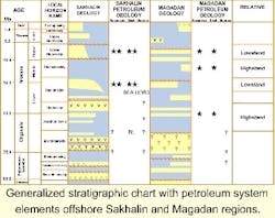
The Cenozoic section attains a maximum thickness of 10-12 km and comprises four main successions: Paleogene, Lower Miocene, Middle-Upper Miocene and Plio-Pleistocene.
Prospectivity
A variety of structural and stratigraphic traps are present through the basins of the region. The most prospective are structural traps associated with Miocene-Pliocene fault movements.
Localized Late Pliocene-Early Pleistocene inversion led to hydrocarbon traps that are relatively small, often-faulted inversion anticlines associated with the major fault zones. The inversion is responsible for the small onshore oil and gas fields, which occur within strongly faulted anticlines associated with the major fault zones of Sakhalin Island and West Kamchatka.
Relatively large, structurally simple, rotated normal fault blocks are common throughout the region and offer potential exploration targets. This has important implications for the development of hydrocarbon accumulations, with the significance of large normal fault blocks having been underestimated in the region as potential hydrocarbon plays.
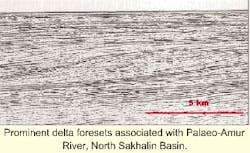
The principal petroleum play in the region is reservoired hydrocarbons in Lower-Middle Miocene sands, sealed by intra-formational muds in a structural (generally reactivated or wrench-related anticlinal) setting and sourced from the Paleogene. The best reservoirs are associated with the paleo-Amur delta system. Gas test rates up to 160 MMcf/d and oil tests up to 12,000 b/d have been recorded. Exploration plays comprise:
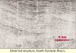
- Pliocene-Miocene sands in structural traps (most common, several large structures remain undrilled)
- Oligocene fractured reservoirs
- Paleogene sands in structural and/or stratigraphic traps.
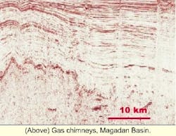
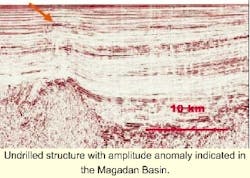
The prospectivity of the offshore Magadan region is harder to assess because little exploration has taken place to date. Only two wells have been drilled, both probably off structure. Prominent gas chimneys visible on the new data attest to an active petroleum system. Potential plays include:
- Lower-Middle Miocene sands in a structural trap
- Upper-Middle Miocene sands in a stratigraphic trap (in particular, basement onlap)
- Paleogene sands in stratigraphic and structural traps
- Paleogene sands in structural/stratigraphic traps.
References
- Very little is published in the English-language scientific literature on the Sea of Okhotsk region. The following papers give an introduction, but are not a complete bibliography.
- Baillie, P.W., Kudelkin, V. and Gilleran, P. A. 2000; Geological development and prospectivity of the Sea of Okhotsk, Far East Russia (Abstract); AAPG Annual Meeting Abstract, New Orleans, Louisiana. AAPG Bulletin 84 (13).
- Khvedchuk, I. 1993; The Petroleum Basins of the Sea of Okhotsk (Abstract); AAPG Bulletin 77 (9), page 1637.
- Jolivet, L., Huchon, P. and Rangin, C. 1989; Tectonic setting of Western Pacific marginal basins; Tectonophysics, 160, 23-47.
- Powell, R.J. 2000; Future Petroleum Potential of the Northeast Sakhalin Shelf (Abstract); AAPG Foundation Pratt Conference: Petroleum Provinces, 21st Century, San Diego, California.
- Rozhdestvenskiy, V. S. 1982; The role of Wrench-Faults in the Structure of Sakhalin; Geotectonics, 16 (4), 331-339.
- Silverman, M. R. 1990; Petroleum Geology of Sakhalin Island, USSR (Abstract). AAPG Bulletin 74 (6), pages 1001-2.
- Simon Technology Limited. 1993; The Petroleum Geology and Hydrocarbon Potential of the Sea of Okhotsk, Russia; Unpublished Report EB005, 5 volumes.
- Worrall, D.M., Kruglak, V.F. Kunst, F. and Kuznetsov, V. 1996; Tertiary tectonics of the Sea of Okhotsk: Far-field effects of the India-Eurasia collision; Tectonics, 15 (4), 813-826.


