Certain critical decisions are made throughout the life of a field. An accurate and evolving geological/reservoir model provides the best basis for each. These include the decisions to acquire the lease, drill the prospect, determine economic viability, design facility type and size, select number and placement of development wells, and find bypassed reserves for infill drilling.
Drilling and producing new wells adds a vast amount of new data. Further seismic acquisition and reprocessing continues to focus model geometries. Technology advances and new interpretation ideas evolve and need to be tested.
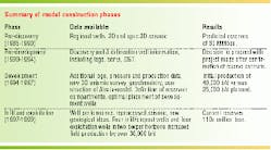
Building an integrated model requires intense and ongoing interaction between the geoscience and engineering staff. Four phases of model building and rebuilding at Lobster Field have occurred: pre-discovery, pre-development, develop ment, and infill/stepout/exploitation.
Location and history
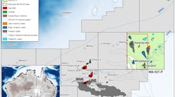
Lobster Field is located in Ewing Bank 873 (EW 873) 130 miles southwest of New Orleans in 775 ft of water. Most of the production is from the Pliocene age Bulminella sand. Lobster was discovered in 1991 and a conventional 30-slot platform installed in the summer of 1994. Oil production from 10 wells peaked initially at platform limits of 48,000 b/d. Simple payout on the platform and development wells was achieved in April 1996.
After declining to 29,000 b/d in 1997, a series of recompletions and acidization work targeting zeolite cement problems stopped the decline. During 1998 and early 1999, Marathon drilled four infill wells in the main Bulminella 1 reservoir. Improved seismic resolution prompted the drilling of four producers in three deeper horizons during this same time. Rates from Lobster Field exceeded 60,000 b/d, following the infill and deeper drilling activity.
Model construction
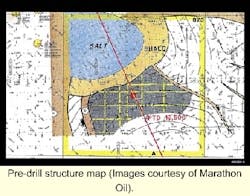
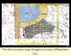
The pre-discovery geological model was a ponded basin floor fan. A salt withdrawal mini-basin was mapped as the sand container. The sands were thought to be sealed by a thick shale section. This model predicted thick, continuous, homogeneous reservoir sands. These were an important consideration in the decision to drill the Lobster prospect, as an economic development would require a minimal number of wells. The EW 873 #1 discovery well and three delineation wells confirmed the pre-discovery model predictions for sand thickness, quality, and continuity.
Comparison of the prospect structure map and current structure maps shows that the early work, based on 2D and poor quality 3D data, correctly identified most of the key structural features. Estimates of productive area and reserves from the pre-discovery model were surprisingly close to the current model.
The first major revision to the model occurred as data from the discovery and delineation wells was integrated with a new 3D seismic survey. The first generation reservoir simulation model was built at that time.
Reserve estimates from that model confirmed the pre-discovery model estimates. However, project economics suffered from poorer than expected oil quality. Lobster oil has an average gravity of 21° API and sulfur content of 3.5%. Accurate modeling of oil quality in this area had been imprecise due to a lack of data. Using the predevelopment reservoir model, a 30-slot platform with waterflood capabilities was designed and fabricated.
Model revision
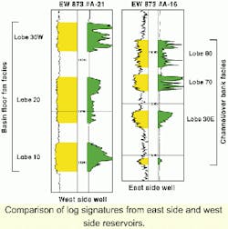
After the platform was set, early development drilling and production resulted in the next major model reconstruction. Log and seismic character, and two whole cores revealed two different facies were present in the reservoir zone.
- On the west side are basin floor fans. The fans are blocky to fining upward, have clean gamma ray and high resistivity log responses. They are correlative and laterally continuous. Fan seismic response is highly reflective, continuous, and divergent to onlapping. Three stacked, individual fan lobes are present. They have a net-to-gross ratio greater than 90%, very uniform character, an average porosity of more than 25%, and permeability of over one darcy.
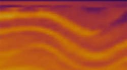
- In contrast, the east-side channel/overbank facies has suppressed log response from numerous shale laminations, is irregular to fining upward, and is difficult to correlate. The channel/overbank seismic signature is more chaotic, discontinuous and mounded. The east-side has two channel/overbank complexes. Both are laminated and heterogeneous with net to gross of 50 to 60%, a porosity of less than 25%, and a permeability in the 300-600 millidarcy range. All hydrocarbon-filled sands in the area have very low seismic impedance, far below wet sand levels. The pays are all bright amplitude events.
A 3D geological model was built at this time and input to a reservoir simulator. Each time a well finished drilling, we loaded the new data and re-ran the reservoir simulator within a period of 24-36 hours. Fast model updating greatly aided optimal placement of later wells.
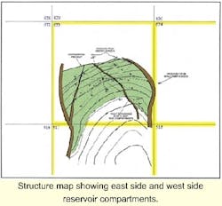
Continued production shows that the east side and west side are separate reservoir compartments. Reservoir pressure data, PVT data, geochemical fingerprinting of produced oil, and different oil/water contacts support the two compartment interpretation.
Infill, deeper drilling
In 1996, another stage of model updating began. Constraint geometry from an inverted, prestack time migrated, 3D seismic data volume set the stage. Better steep-dip migration revealed new structure and reservoir details. Understanding of sand body and salt geo metries improved. Reconstruction of the basin formation via regional mapping of salt and sequence boundaries clarified prospects.
Recent regional studies aided our inter pretations. Regional and detailed integration yielded the current geological model that guided the latest infill drilling program and pointed the way to the discoveries in two deeper fan packages.
Current geological model
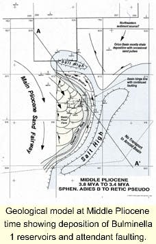
A massive salt canopy was emplaced near the end of the Miocene. Onto the salt canopy, large basin floor fans were deposited during the early Pliocene. The major sand source during this time is from the northwest. During the Middle Pliocene, basin floor fan deposition into the Lobster basin included the west side Bulminella 1 reservoirs. Basin loading resulted in the development of salt highs around its margin.
A depo-shadow due to the blocking of sediment influx by the salt high developed on the northern margin of the Lobster basin. Extensive basin-rim normal and perhaps tear faulting developed in response to basin growth and loading.
During Middle Pliocene time the final stage of deposition was the large channel/overbank complex forming the east side Bulminella 1 reservoirs. During the Late Pliocene, the amount of sand being deposited dwindled. Isolated channel/overbank systems prevailed. The salt highs became more pronounced.
Faulting accelerated and basin touchdown, with salt weld formation, probably occurred during this time. A major depositional hiatus occurred at the end of the Late Pliocene. The sand source shifted further west and foramini fera-rich marls were deposited. Over 200 ft of this marl that accumulated over a period of approximately 1.9 million years clearly indicates the Pliocene/Pleistocene sequence boundary.
Summary
An evolving geological and reservoir model continually updated with new data and interpretations has proven to be a successful exploration and field management tool. Geological and reservoir modeling has had a large profit impact on Lobster Field from the initial concept to the present infill drilling program.
Improved seismic technology revealed key relationships and new opportunities. Intense teamwork between geoscientists and engineers has been the key to successful management.;
References
Edman, J., Burk, M., "An integrated study of reservoir compartmentalization at Ewing Bank 873," SPE 49246, 1998 AAPG/EAGE Research Symposium on Compartmentalized Reservoirs: Annual Technical Conference, New Orleans, LA, September, 1998.
Petro, D., Chu, W., Burk, M., Rogers, B., "Benefits of pressure transient testing in evaluating compaction effects: Gulf of Mexico deepwater turbidite sands," SPE 38938, Annual Technical Conference, San Antonio, 1997.
Rogers, B., Burk, M., Stonecipher, S., "Designing a remedial acid treatment for Gulf of Mexico deepwater turbidite sands containing zeolite cement," SPE 39595, SPE International Symposium on Formation Damage Control, Lafayette, Louisiana, 1998.
Rowan, M., Weimer, P., "Salt sediment interaction, northern Green Canyon and Ewing Bank (offshore Louisiana) northern Gulf of Mexico," AAPG Bulletin, v.82, 1998.
Uland, M., Tinker, S., Caldwell, D. "3-D reservoir characterization for improved reservoir management," SPE 37699, SPE 10th Middle East Oil Show and Conference, Manama, Bahrain, 1997.
Varnai, P., "Three dimensional seismic stratigraphic expression of Pliocene-Pleistocene turbidite systems, northern Green Canyon (offshore Louisiana), northern Gulf of Mexico," AAPG Bulletin, v. 82, 1997.
Weimer, P., Varnai, Budhijanto, F., Acosta, Z., Martinez, R., Navarro, A., Villamil, T., Arango, C., Rowan, M., McBride, B., Pulham, A., Crews, J., "Sequence stratigraphy and depositional history of Plio-Pleistocene sediments, northern Green Canyon and Ewing Bank, northern Gulf of Mexico," AAPG Bulletin, V. 82, 1998.
