Offshore staff
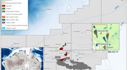
WEST PERTH, Australia – CGG Multi-Physics will start a multi-client airborne gravity, gravity-gradiometry and magnetics survey later this month for Searcher Seismic over near-shore areas in the Gulf of Papua.
The Roho survey will cover a 60,700-sq km (51,000 line km) area along the southern coast ofPapua New Guinea (PNG).
It follows several recent marine seismic and geochemical projects undertaken by the company to assess the hydrocarbon potential of the Gulf of Papua and adjacent Coral Sea areas.
Rachel Masters, Searcher’s global sales manager, said: “PNG has become an area of increasing industry interest in recent years and successful exploration and development projects onshore have ignited interest in the potential prospectivity offshore, which is largely unexplored.”
Much of the area covered will comprise shallow water transition zone environments where seismic operations are difficult and expensive, Masters said, adding that Roho would “provide companies with a cost-effective tool to assess these areas and effectively focus future exploration efforts.”
CGG will operate a Basler BT-67 twin turbine fixed wing aircraft for the program. Final data should be available early next year with a regional interpretation of the new data due to be completed by June 2018.
Searcher Seismic has also entered the Argentine sector with four new multi-client projects.
The first phase is an Offshore Basin Analysis Report providing a regional framework to understandArgentina’s offshore basins, thereby assisting the industry’s exploration efforts. It features a single stratigraphic scheme with various new play concepts, ranging from Permian to Miocene and is available now.
Also part of this phase is the newly under way Malvinas basin 2D reprocessing project, comprising around 15,000 km (9,320 mi) of existing data over the West Malvinas basin failed rift basin.
The next phases of the campaign will be the Malvinas basin non-exclusive 2D seismic survey, covering an area of around 11,000 km (6,835 mi) and tying 18 exploration wells, and a Malvinas basin seep detection program, both scheduled to start this year.
Masters said: “The Malvinas basin in particular offers high-impact, moderate risk exploration in shallow water, with a bid round expected to be announced later this year.”
11/02/2017
