TGS to expand 2D seismic coverage offshore northwest Africa
Offshore staff
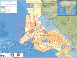
ASKER, Norway – TGS plans to expand its NWAAM multi-client library in the MSGBC basin offshore northwest Africa by acquiring more than 11,500 km (7,146 mi) of long-offset broadband 2D seismic data, along with magnetic and gravity data.
The focus of the campaign will be over waters offshore the Republic of Guinea, Guinea Bissau, and the AGC joint exploration zone between Guinea Bissau andSenegal.
TGS is conducting the program in cooperation with PGS and GeoPartners. TheBGP Dong Fang Kan Tan vessel is due to start work on the first phase next month.
The NWAAM2017 seismic survey has been designed to infill, extend, and complement the TGS NWAAM2012 2D survey which assisted analysis of recent commercial discoveries in the MSGBC basin.
A 12-km (7.5-mi) deep-tow streamer will facilitate recording of high quality broadband 2D seismic data to image the pre-rift, syn-rift, and post-rift plays.
TGS currently has more than 28,000 km (17,398 mi) of 2D data and more than 18,000 sq km (6,950 sq mi) of 3D data over the basin.
Elsewhere, TGS and PGS have continued their programoffshore eastern Canada, this May embarking on their sixth consecutive season acquiring data in the area.
By season-end they anticipate acquiring around 2,000 sq km (772 sq mi) of 3D data and 38,000 km (23,612 mi) of 2D seismic offNewfoundland and Labrador.
During 3Q, TGS completed acquisition of the 8,000-km (4,971-mi) long-offset broadbandNorthwest Shelf Renaissance 2D seismic survey.
This was designed to tie recent and deep wells with TGS’ existing 3D coverage in the Exmouth Plateau/Carnarvon basin and crosses acreage included in the 2016 Australian licensing round.
TGS has also completed acquisition of a multi-year 2D program offshore northeastGreenland, totalling about 15,000 km (9,320 mi) of data. Final processed results are expected to be available to clients in late 1Q 2017.
10/28/2016
