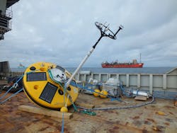
Fugro supports Technip’s largest North Sea project
Offshore staff
LEIDSCHENDAM, the Netherlands – Real-time metocean data transmitted by a Fugro SEAWATCH Wavescan buoy is enabling Technip to plan its operations more effectively for its largest UK North Sea contract to date. Located in the west of Shetland area, BP’s Quad 204 project involves replacing the existing Schiehallion production facility with a new, purpose-built FPSO and installing extensive new subsea infrastructure.
Fugro Commercial Manager Jonathan Ainley said, “West of Shetland is known as a harsh offshore environment with big waves and strong currents – conditions that are far from ideal in a construction setting. BP specifically required reliable real-time wave height, wind, and current data to manage its installation criteria thresholds. Access to these metocean data is also critical for vessel management and for safe and efficient operational planning.”
The SEAWATCH Wavescan buoy, manufactured by Fugro in Norway, is 2.8 m (9.2 ft) in diameter, with a counterweighted keel to prevent capsizing. It is large enough to cope with the harsh North Sea conditions. A 3.5-m (11.5-ft) mast supports the buoy’s meteorological sensors and antennae, while a range of subsea sensors monitor oceanographic conditions.
During its nine-month deployment, sensors will collect oceanographic and meteorological data including air pressure, air temperature, current velocity/direction, and water temperature. Current profilers will be used in two locations (one just below the buoy and another further down the mooring) to build a current profile for the full water column depth. Wave data parameters to be measured include heave, surge, sway, direction, height, and wave period.
The buoy transmits the data by satellite to Fugro, where it is presented in real time on a Website that uses a variety of user-friendly pages and options, including a graphic format (to display current velocity/direction information for the full water column depth) and tabular data.
10/07/2014
